|
|
| |
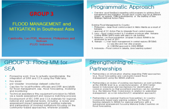
 3. FMM 3. FMM
|
| |
1. ПЌБИРЧ ЧЪПфМК
Necessity for Study
|
| |
|
СіГ 30ГтАЃ Рќ ММАш РкПЌРчЧиРЧ 38%АЁ ОЦНУОЦСіПЊПЁМ ЙпЛ§ЧЯПДРИИч, ЖЧ РчЧиЗЮ РЮЧб РЮИэ ЧЧЧиРЧ 90%АЁ ОЦНУОЦПЁМ ЙпЛ§ЧЯАэ РжДйДТ АЭРК ОЦНУОЦРЧ РчЧиУыОрМКРЛ ЙнПЕЧЯИч БтСИРЧ ЙцРчБтМњЗЮДТ БтШФКЏШДыРРАњ РчЧиАцАЈПЁ ЧбАшАЁ РжРНРЛ НУЛчЧбДй. РчЧиЙпЛ§РЏЧќКА ЧіШВРЛ ЦФОЧЧб АсАњ ШЋМі Йз ЕЙЙпШЋМі РчЧиКѓЕЕАЁ ДйИЅ РчЧиЙпЛ§АЧЕЕАЁ ИЙБт ЖЇЙЎПЁ РЬПЁ ДыЧб С§СпРћРЮ ДыУЅЙцОШ ЧЪПфЧЯДй. ЖЧЧб УжБй БтШФКЏШ Йз БтЛѓРЬКЏПЁ ЕћИЅ ШЋМіЧЧЧи СѕАЁЗЮ РЮЧи РЮРћ Йз РчЛъ ЧЧЧиАЁ СѕАЁЧЯДТ УпММРЬБт ЖЇЙЎПЁ ШЋМіЧЧЧи РњАЈ ЙцОШПЁ ДыЧб ШПРВРћРЮ Action Plan СІНУАЁ ПфБИЕШДй.
|
| |
|
The fact that 38% of natural disasters world wide occurred in the Asian region over the past 30 years, and that 90% of casualties due to overall disasters occurred in Asia reflects the vulnerability of Asia to disasters. This suggests that there exist limits to the current disaster prevention and relief technology caused by climate changes among others. A careful review of the current status of disasters occurring by type shows that sudden flooding occurs more frequently than any other type of disasters, suggesting that concentrative measures dealing with flooding are required. Moreover, with loss of human lives and damage to properties steadily being on the rise due to increases in damages caused by flooding as a result of climate changes and abnormal changes in the weather, an efficient Action Plan that will reduce damages caused by flooding is required.
|
| |
2. ЧЯУЕШЋМі РњАЈЛчОїАњ ПЌАшЕШ Action Plan
Action Plan linked with river flooding reduction programs
|
| |
- Conduct research and develop methodologies/models for making future climate projections for cross border hazards such as shared river basins. [ЅА-A-1] [ЅБ-F-1]
- Review/update/establish institutional mechanisms and financial reserves for facing displacement and livelihood needs. [ЅА-A-2]
- Take stock of existing training programmes and promote their availability to other regions of Asia. [ЅА-B-1]
- Regional partnership to systematically engage national training centres. [ЅА-B-1] [ЅБ-E-1] [ЅВ-A-3]
- Develop user friendly awareness building materials on DRR and CCA for use of the media. [ЅА-C-1] [ЅБ-B-2]
- Develop programme with environment, agriculture, water resources and other relevant ministries in the existing programmes. [ЅА-C-4]
- Develop partnership with universities, research institutes, and develop course module for graduate and post-graduate programmes. [ЅА-C-5]
|
| |
|
3. ЧЯУЕШЋМі РњАЈЛчОї УпСјСіПј, 4АГБЙ (ЕПГВОЦНУОЦСіПЊ)
|
| |
| Country |
Location |
Capital |
Time zone |
Climate |
Official language |
Political System |
| Cambodia |
South-western part of East Asia, the IndochinesePeninsula |
Phnom Penh Indochinese Peninsula I |
UTC+7 |
Tropical Monsoon |
Khmer |
Constitutional
Monarchy |
| Laos |
The IndochinesePeninsula |
Vientiane |
UTC+7 |
Hot and humid, affected by tropical monsoon climate. |
Laotian |
Socialist Republican |
| Vietnam |
Eastern part of the IndochinesePeninsula |
Hanoi |
UTC+7 |
Tropical monsoon prevailing except high altitudes |
Vietnamese |
One-party dictatorship |
| Miyanma |
South-east Asia, Southern part of China,North-westernpartoftheIndochinesePeninsula |
Naypyiadaw |
UTC+6.5 |
Tropical seasonal wind prevailing |
Myanmarese |
- |
|
| |
4. МБЧр ЧСЗЮСЇЦЎ ЕПЧт
Trends of Previous Studies
|
| |
|
1Тї БЙСІШИРЧ АГУж(GFDRRАњ АјЕПАГУж)ИІ ХыЧи ЧЯУЕШЋМі УпСјБЙАЁПЁ ДыЧб РЮРћГзЦЎПіХЉ БИМК Йз ПЌБИЙцОШ ГэРЧИІ ХыЧи ПЌБИБтШЙОШРЛ ЕЕУтЧЯПДРИИч, ЧЯУЕШЋМі УпСјБЙАЁ(ФЏКИЕ№ОЦ, ЖѓПРНК, КЃЦЎГВ, ЙЬОсИЖ)КА КёБИСЖРћ ДыУЅ ЙцОШ(ПЙАцКИ НУНКХл) КёБГ КаМЎРЛ ХыЧб ПЌБИБтШЙРЛ МіЧрЧЯПДДй. ЖЧЧб, ЙАКаРя СіПЊРЮ ИоФсА РЏПЊРЬ УпСјБЙЕщ Сп ЖѓПРНК, ФЏКИЕ№ОЦ, КЃЦЎГВ, ЙЬОсИЖ И№ЕЮ ЦїЧдЕЧОю РжОю СпСЁРћ АЫХфЧЯПДДй.
|
| |
|
A study plan was derived through construction of manpower network and discussion over study methods for the countries implementing programs of counter-river flooding by holding the first international conference (GFDRR jointly held), and a study program was conducted through a comparative analysis of non-structural measures (precautionary warning system) by counter-river flooding implementing country (Cambodia, Laos, Vietnam, Myanmar). Moreover, Laos, Cambodia, Vietnam and Myanmar among the regions disputing over water supply along the River Mekong are all included in the program, and reviewed with a focus.
|
| |
|
| |
5. БтСИ РњАЈЙцЙ§РЧ ЙЎСІСЁ
Problems of the existing reduction methods.
|
| |
|
МіЙЎЧаРћ СЄКИ ЂЁ PDF ЦФРЯЗЮ ЧЅУт(РкБЙО№Ою), МіСњАќУј И№ДЯХЭИЕРЬ СіЕЕЗЮ ЧЅУтЕЧИч, РќЙнРћРИЗЮ НУНКХл БИМКРЬ УЪКИРћ МіСиРИЗЮ НЧНУАЃ РкЗс ЧЅУт НУНКХл Ею БтКЛРћРЮ ЧЅУт НУНКХлРЬ БИМКЕЧОю РжСі ОЪДй. ЛѓШВРИЗЮ ШЋМіРЇЧшПЙКИБюСі ЧбЙјПЁ БИМКЧЯБтПЁДТ ЙЋИЎАЁ РжДТ АЭРИЗЮ ЦЧДмЕШДй(ГтТїКА АшШЙРЬ ЧЪПф). Weather Report(ПТЕЕИІ ЧЅЗЮ ЧЅУт), Earthquake, Rader Images, Satellite Imaged, Weather Chart, NWP, Aviation, Hydrology, Weather Forecast, Climatology, Meteogram ЧіРчМіРЇ, АцКИМіРЇ, РЇЧшМіРЇЗЮ БИКаЧЯПЉ ЧЅЗЮ ЧЅУтЕЧИч, GIS View ЧЅУт НУНКХл ЙЬШэ: РќЙнРћРИЗЮ НУНКХл БИМКРЬ УЪКИРћРЮ МіСиРЬДй.
|
| |
|
Hydrological information ЂЁ Expressed in PDF files (native tongue), water quality monitoring is expressed by maps and the system composition is on an elementary level, with no basic expression system constituted such as real-time data expression system. The current situation doesn't seem to allow the authorities concerned to build data including flooding risk forecasting (Year by year planning is needed). Divided into weather report( Temperature is expressed by means of tables), earthquakes, radar images, satellite Images, weather charts, NWP, aviation, hydrology, weather forecast, climatology, meteogram, current water level, warning water level and the risky water level, the information is expressed by means of tables. The GIS View expression system is insufficient, and overall system building is on an elementary level.
|
| |
|
| |
(2) БЙГЛПм ПЙАцКИНУНКХл КёБГКаМЎ
(A Comparative Analysis of Precautionary Warning System from home and abroad)
|
| |
| Category |
Measurement/Monitoring/Data System |
Real-time data linkable model and identification of areas affected by disasters |
Building a warning system |
БЙ ГЛ
БтМњЧіШВ
Current status of domestic technology |
Ём ПьМі(МБСјБЙ МіСи)
Excellent (level of advanced countries)
Ём GIS View
Ём МіЙЎ, МіИЎЧаРћ РкЗс БИУр
Building hydrological data
Ём НУНКХл ПьМі
System evaluated as excellent |
Ём БтСИ : РкЗс ЧЅУтРЛ ХыЧб И№ДЯХЭИЕ НУНКХл
Existing: Monitoring system by expressing data
Ём УжБй : НЧНУАЃ РкЗс ПЌАшИІ ХыЧб МіЙЎ, МіИЎ, МіСњ И№ЕЈРЛ БИЕПЧЯПЉ ПЙУј АЁДЩ
Latest: Predictable by putting into operation hydrologic and water quality models through real-time data linkage
Ём ШЋМіРЇЧшСіЕЕ(ПьМі)
Flooding risk maps evaluated as excellent.
Ём EAP(ПьМі)
EAP(Excellent) |
Ём ЧкЕхЦљРЛ РЬПыЧб АцКИНУНКХл УМАш БИУр(ПьМі)
Warning system construction using cell phone
(Excellent)
Ём РќБЄЦЧ Ею ЧЅУтНУНКХл БИУр(ПьМі)
Display system construction such as electronic display board (Excellent)
Ём АцКИ НУНКХл БИУрРК IT БтЙнАњ ЙаСЂЧб АќАшЗЮ БЙГЛРЧ АцПь ПьМіЧб НУНКХл
Warning system construction is rated excellent domestically owing to close relationship with IT base. |
ЧЯУЕШЋМі
УпСјБЙЕщ
БтМњЧіШВ
The technological status of counter-river flooding program participant countries |
Ём ИоФсА РЇПјШИПЁМ БИУрЧб ШЋМіПЙАцКИ НУНКХлРК ОчШЃ
The flooding preparatory warning system built by the Mekong Committee evaluated as good
Ём АшУј НУНКХлРЧ АцПь БЙАЁ АцСІЙпРќАњ ПЌАќРЬ РжБт ЖЇЙЎПЁ СіУЕ Йз КЛЗљПЁ ДыЧб АшУјНУНКХл Йз РкЗс БИУрРК ЙЬШэ
Since the measurement system is related with the nationЁЏs economic development, the measurement system and data construction for triutaries and the main stream are insufficient. |
Ём МіФЁИ№ЧќРЛ РЬПыЧб ЧіРч Йз ПЙУјРкЗс ЧЅУт (АќУјРкЗсПЭ КёБГКаМЎ Ею) -> 1ТїПј МіИЎКаМЎ И№ЕЈ РћПы
Present and prediction data expressed using numerical models (Observation data and comparative analysis, etc.) -> 1stdimensionnumericalanalyticmodelapplied
Ём НЧНУАЃ АќУј РкЗс ПЌАш КЮКаРК ЦФОЧ ЧЪПф
The part associated with time observation data needs grasping.
Ём ШЋМіРЇЧшСіЕЕ КЮКа ЙЬШэ
The part of water-level risk ma maps remains insufficient.
Ём ЕЙЙпШЋМі КЮКа ЙЬШэ
The part ЁАsudden floodingЁБ remains insufficient.
Ём УМАшРћРЮ EAP МіИГ ЧЪПф
EAP needs to be established systematically. |
Ём ДыБЙЙЮ ШЋКИ Йз ОШСЄМК ШЎКИИІ РЇЧб СЖСїРћРЮ АцКИ УМАшДТ ЙЬШэ
Systematic warning system to to secure publicity for the nation is rated insufficient. |
|
| |
5. БтСИ РњАЈЙцЙ§РЧ ЙЎСІСЁ
Problems of the existing reduction methods.
|
| |
(1) ЧЯУЕАќИЎ РкЗс ЧЅСиШ НУНКХл БИУр
(Construction of river management data standardization system)
|
| |
Ём ШЋМіЙцОю НУНКХл БИУр НУ ЧЯУЕАќИЎ(ЧЯУЕ, МіИЎБИСЖЙА Ею) Йз ЧЯУЕСЖЛч(УјСЄРкЗс, АшУјРхКёЕщРЧ МіНХРкЗс)РЧ РкЗс ЧЅСиШИІ ХыЧи ШПРВРћ РЏСі АќИЎ УМАш БИУр
Ём To build efficient a maintenance and management system through standardization of river management (river, hydraulic structures, etc.) and river survey (measuring data, data received via instrumentation equipment) data.
|
| |
- ЧЯУЕСЖЛч Йз АќУјРкЗс БтМњПЁ ДыЧб ЧЅСиШ И№Чќ СІНУ
- Presentation of standardized models for river survey and observation data technology
|
| |
- РЏПЊ, ЧЯУЕ, ЙшМіНУНКХл Йз МіИЎБИСЖЙАПЁ ДыЧб БтМњ ЧЅСиШ ЙцОШ
- Measures of standardizing technology for river-beds, rivers, water drainage systems and hydraulic structures
|
| |
- МіЙЎ АќУј РхКё Йз ЧЯУЕАќУј РхКёЕщПЁ ДыЧб МіНХРкЗс ЧЅСиШ ЙцОШ
- Received data standardization measures for hydrologic observation equipment and river observation equipment
|
| |
|
Ём БтДыШПАњ Desired Effects
|
| |
- ШЋМіАќИЎ НУНКХлРЧ ШПРВРћ РЏСіАќИЎ СѕДы ШПАњ
- Effects of expanded efficient maintenance of the flooding management
|
| |
- БЙАЁАЃРЧ ШЋМіЙцОю ПЌАшНУНКХлРЧ ШПРВМК СѕДы
- Enhanced efficiency of cross-border flooding prevention linkage systems
|
| |
- БЙАЁАЃРЧ БтМњРЬРќРЧ ПыРЬ
- Cross-border technology transfer made easier
|
| |
(2) РчЧиРЏЧќКА СіПј БЙАЁПЁ ДыЧб СЄКИМіС§ ЙцЙ§ БИЛѓ
(Proposed ways of collecting data on supportive countries by type of disaster)
|
| |
Ём РчЧиРЏЧќКА СіПјБЙАЁЕщПЁ ДыЧб ШПАњРћРЮ РчГСЄКИ УМАш ЦФОЧ АЁДЩ
Ём Systematic grasp of effective disaster information for supportive countries by type of disasters made possible
|
| |
- ПЙАцКИНУНКХл Йз ЧтШФ БИСЖРћ ДыУЅ СіПј ЧіШВЦФОЧ АЁДЩ
- Grasp of the current status of precautionary warning system and support to subsequent structural measurement made possible
|
| |
Ёц БЙГЛ ЛъОїУМ ТќПЉИІ РЇЧб СЄКИ СІАј АЁДЩ
Ёц Provision of Information for the participation of domestic industries made available.
|
| |
|
Ём СЄКИМіС§ ЙцЙ§ Methods of collecting information
|
| |
- РЮРћГзЦЎПіХЉИІ ХыЧи СЄКИУМАш, ПЙУјИ№Чќ Йз ШЋМіПЙАцКИНУНКХл АГЙп ЧіШВ ДмАшКА ЦФОЧ Йз ЧиДчБЙАЁ ПфБИЛчЧзПЁ ДыЧб БИУМРћ БтМњ ЙЎМ МіС§
- To grasp the current status of information system, prediction models and the development of flooding preparative warning systems and collect specific technological literature responsive to requirements of the countries concerned.
|
| |
(3) ЕЕНУСіПЊ ШЋМіЙшСІ НУНКХл Йз ШЋМіРЇЧшСіЕЕ БИУр
(Construction of urban area flooding exclusion systems and flooding risk maps)
|
| |
Ём ИоФсА РЇПјШИРЧ БтСИ ШЋМіПЙАцКИ НУНКХлРЧ АцПь АнРкХЉБтАЁ 50 kmЁП50 kmЗЮ ЧиЛѓЕЕАЁ ЛѓДчШї ГЗОЦ ЕЕНУСіПЊПЁ ДыЧб ШЋМіЙцОюДыУЅРЛ РЇЧиМДТ ЧиЛѓЕЕРЧ ЧтЛѓРЛ ХыЧи КИДй СЄШЎЧб ШЋМіРЇЧшСіЕЕ БИУрРЬ ЧЪПфЧЯДй. ЦЏШї ЕЕНУСіПЊРЧ АцПь ЙшМіНУНКХлАњ ПЌАшЧб ШЋМіЙцОюДыУЅ МіИГРЛ ХыЧи РЮИэ Йз РчЛъЧЧЧиИІ УжМвШЧдРЬ ШПАњРћ
Since in the case of the existing flooding precautionary warning system of the River Mekong, the matrix measuring 50 km x 50 km has a low resolution, more precise flooding risk maps need to be constructed for the enhancement of resolutions. In the case of urban areas in particular, minimization of loss of human lives and properties is effective by building flooding prevention systems linked with the drainage system.
|
| |
- ЕЕНУСіПЊПЁ ДыЧб ШЋМіРЇЧшСіЕЕ РлМК НУ ЧиЛѓЕЕ ЧтЛѓ(ПЙ: 90m*90m)
- In making flooding risk maps for urban areas, resolutions need to be enhanced (e.g. 90m*90m).
|
| |
- ЧЯУЕПЁ ДыЧб МіИЎЧаРћ И№Чќ, ЕЕНУРЏУтИ№ЧќРЛ ПЌАшЧб ШЋМіЧЧЧи КаМЎ И№ЕЈ РћПы
- To apply flooding damage analytical models linked with hydrologic models for rivers and urban drainage models.
|
| |
|
- ЦпЧСРх ПюПЕЙцОШ МіИГ Ею
|
| |
- ШЋМіРЇЧшСіЕЕ РлМК
- To make flooding risk maps
|
| |
|
Ём БтДыШПАњ Desired effects
|
| |
- ШЋМіРЇЧшСіЕЕ РлМКРК EAP МіИГАњ ПЌАшНУФб РЮИэ ЧЧЧи УжМвШ
- To minimize lost lives linked with the establishment of EAP in preparing flooding risk maps
|
| |
- ШЋМіПЙАцКИНУНКХл БИУрАњ ШПРВРћ ПЌАш АЁДЩМКРИЗЮ РЮЧи ШЋМіЙпЛ§НУ ЛѓШВРќЦФПЁ ДыЧб РЧЛчАсСЄ СіПјРЬ АЁДЩ
- Support to making decisions on disseminating the status quo made possible in case a flood has erupted thanks to efficient linkage possibility with flooding precautionary and warning system construction
|
| |
- ШЋМіЙцОюПЁ ДыЧб БИСЖРћ ДыУЅ МіИГ ЦФОЧРЛ ХыЧи БЙГЛБтОї ШЋМіЙцОю УМАш БИУр МіУт СѕДы
- To build flooding prevention system on the part of the domestic industry by ensuring structural measuring plans are ready for flooding prevention.
|
| |
(4) НЧНУАЃ РкЗс ПЌАшИІ ХыЧб ШЋМіПЙАцКИНУНКХл БИУр
(Construction of flooding precautionary and warning system by linking real-time data)
|
| |
Ём ШЋМіПЙАцКИ НУНКХл БИУр НУ АќУј РхКёЗЮКЮХЭ МіНХЕШ РкЗсЕщПЁ ДыЧб НЧНУАЃ И№Чќ ПЌАшИІ ХыЧи РЧЛчАсСЄРкРЧ НХМгЧб ШЋМіЛѓШВ РќЦФ Йз РЧЛчАсСЄРЧ БиДыШ
Ём To promptly disseminate the status quo of flooding and maximize decision-making by linking real-time models for data received via observation equipment.
|
| |
- НЧНУАЃ ШЋМіПЙАцКИНУНКХл БИУр - БЙАЁРЧ АцСІРћ Йз СіПЊРћ ЦЏМКРЛ АэЗСЧб АќУј И№ДЯХЭИЕ БтМњ АГЙп
- Construction of real-time flooding precautionary warning systems - development of observation and monitoring technology that has taken into consideration the countryЁЏs economic and regional traits
|
| |
- "ЕЕНУСіПЊ ШЋМіЙшСІ НУНКХл Йз ШЋМіРЇЧшСіЕЕ БИУр" БтШЙПЌБИПЁМ АГЙп ЖЧДТ РћПы АЁДЩЧб И№ЧќРЛ НУНКХлПЁ БИУр
- Construction of models developed or applicable by proposed study entitled "Construction of an Urban area flooding exclusion system and flooding risk maps"
|
| |
- ШЋМіЛѓШВ РЧЛчАсСЄ НУНКХл БИУр
- To build a decision-making system for flooding status
|
| |
|
Ём БтДыШПАњ Desired effects
|
| |
- ШЋМіПЙУјРЛ ХыЧи РЮИэАњ РчЛъЧЧЧи УжМвШ
- Minimization of loss of human lives and properties
|
| |
- РЏСіАќИЎ Йз ПюПЕПЁ ЧЪПфЧб БтМњСіПј Йз И№ЧќБИУрРЛ ХыЧи МіРЭ УЂУт АЁДЩ
- Technological support to maintenance and operation, and income generation made possible
|
| |
- БЙГЛ АќУј РхКё Йз АшУјБтМњ МіУт ШПАњ
- Exports of domestic observation equipment and measuring technology expected
|
| |


