|
|
|
| DRR-TAG АзіӯҫИАь |
Home > R&D > DRR-TAG > Region Disaster > 1. GLOF |
|
|
|
|
| |
 1. GLOF 1. GLOF
|
| |
1. ҝ¬ұёАЗ ЗКҝдјә
Necessity for Study
|
| |
|
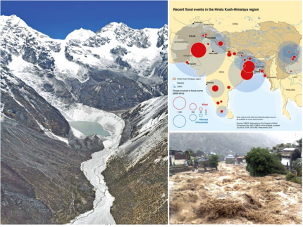
ЗцАз ұвИД ҝВіӯИӯҝЎ АЗЗШ ИщөОДнҪГ-Ичё»¶уҫЯ (HKH) БцҝӘ әщЗПАЗ ё№Аә әОәРАМ ҫгҫЖБц°ЕіӘ ім°н АЦАёёз, ұЧ °б°ъ әщЗП ё»ҙЬҝЎ ЗьјәөЗҫоАЦҙВ әщЕрј®Аё·О ЗьјәөИ АЪҝ¬ ҙп ҫИВКҝЎ әщЗП И«јц №Я»эЗП°н АЦҙЩ. АМ·ұ әщЗП ИЈјцөйА» ЗьјәҪГЕ°°н АЦҙВ АЪҝ¬ ҙпАО әщЕрј® ҙпАә әщЗПАЗ °ијУАыАО ҝлА¶ҝЎ АЗЗС јцА§ Бх°Ў, БЦәҜАЗ »к»зЕВіӘ ҙ«»зЕВҝЎ АЗЗШ әШұ«өЗ°ЕіӘ ҪәҪә·О әШұ«өЙ °ЎҙЙјәАМ іфАёёз АМҝЎ АЗЗШ ЗьјәөИ ө№№Я И«јцҙВ ЗП·щҝЎ ё·ҙлЗС ЗЗЗШ ГК·ЎЗСҙЩ. Ичё»¶уҫЯҝН АҜ»зЗС БцҝӘҝЎ іӘЕёіӘ°н АЦҙВ АМ·ҜЗС Зц»уөйА» АПДГҫо әщЗП И«јц(GLOF)¶у°н әОёҘҙЩ. 1985ҝЎҙВ іЧЖИАЗ ДсәОИчё» БцҝӘҝЎ АЦҙВ әщЗП И«јц Dig TshoАЗ №ь¶чАё·О АОЗШ °ЕАЗ ҝП°шөЗҫъҙш іІГј јТұФёр јц·В№ЯАь ЗБ·ОБ§Ж®°Ў ёрөО ЖДұ«өЗ°н ЗП·щБцҝӘАМ ё·ҙлЗС ЗЗЗШёҰ АФАә »з°ЗАМ АЦҫъҙЩ. БЯұ№ҝЎјӯ №ь¶чЗС әщЗПИЈ ИЈјц°Ў іЧЖИ, АОөө, әОЕәұоБц ЗЗЗШёҰ АФИчҙВ өо, GLOFөйАә ұ№°жА» ГКҝщЗШјӯ ҫЗҝөЗвА» БЦ°н АЦҙЩ.
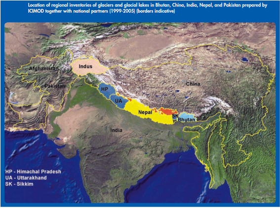
әОЕә, БЯұ№, АОөө, іЧЖИ°ъ ЖДЕ°ҪәЕәАё·О ұёјәөИ 5°і ИщөО ДнҪГ-Ичё»¶уҫЯ БцҝӘАЗ әщЗПЎӨәщЗПИЈ ёс·ПҝЎҙВ ГСёйАы 33,344 sq.kmАЗ 8,790°і әщЗПИЈ°Ў ұв·ПөЗҫо АЦАёёз ұЧ БЯ 204°і°Ў АбАзАыАО А§ЗиИЈјц·О әР·щөЗҫъҙЩ. ЖДЕ°ҪәЕә, АОөө, ҫЖЗБ°ЎҙПҪәЕә, №Мҫбё¶ өоҝЎ әРЖчЗПҙВ әщЗП ИЈјцҙВ АМ ёс·ПҝЎјӯ ҙЩ·зҫоБцБц ҫКҫТұв ¶§№®ҝЎ ҪЗБҰ ИщөО ДнҪГ-Ичё»¶уҫЯ БцҝӘАЗ әщЗПИЈјцАЗ ГСұФёрҙВ ёс·ПАЗ ұв·ПәёҙЩ ҙх ё№А» °НАМҙЩ.
|
| |
|
Many parts of the glaciers of the Hindukushi-Himalayan region is either thinning or melting due to the warming of the earth, causing as a result glacier lakes inside the natural dam made up of moraines formed at the bottom of the glaciers. Moraine lakes, which are natural dams making up such glacier lakes, are likely to rise in the water level due to continuous fusing of glaciers, are likely to collapse by landslides and avalanches or cave in naturally, and such abrupt flooding causes tremendous damages to the lower reaches. Such phenomena that occur in regions similar to Mt.Himalaya are dubbed GLOF. Flooding of the GLOF Dig Tsho in the Kumhuhimal region, Nepal, which erupted in 1985, destroyed the Nimche minor hydroelectric power plant project, causing tremendous damages to the lower reaches of the river. The glacier lakes that flooded in China affected as far as Bhutan, India, Afghanistan, Myanmar and so forth, thus adversely affecting regions beyond national boundaries. The list of glaciers and glacier lakes in the 5 Hindukushi-Himalayan regions made up of Bhutan, India, Nepal and Pakistan comprises 8,790 glaciers covering a total of 22,344 square kilometers, of which 204 are classified as potentially dangerous lakes. Since glacier lakes distributed in Pakistan, India, Afghanistan, Myanmar and so forth are not dealt with in the list, the total scale of the glacier lakes would be much larger than the record on the list.
|
| |
|
| |
|
әщЗПИЈ ИЈјцөйАә ЗП·щҝЎ °ЕБЦЗПҙВ °шөҝГјөйҝЎ°Ф Е« А§ЗщАМ өЗ°н АЦБцёё, өҝҪГҝЎ іуҫч°ъ »кёІАЪҝшҝЎ АЗБцЗПҝ© »мҫЖ°ЎҙВ °шөҝГјёҰ А§ЗС јцАЪҝшАё·ОјӯАЗ °ЎҙЙјәА» °®°н АЦұвөө ЗПҙЩ. ИЈјц №ь¶чАЗ А§ЗиА» ГЦјТИӯЗП°н АОұЩ °шөҝГјөйАЗ ГлҫајәА» әёИЈЗПҙВ өҝҪГҝЎ әщЗПИЈ·ОәОЕН ҫтА» јц АЦҙВ °ЎҙЙјә ¶ЗЗС БцЕ°ҙВ °НАМ ЗцАз ҝмё®°Ў ЗШ°бЗШҫЯЗТ іӯБҰАМҙЩ. АМёҰ А§ЗШјӯҙВ ёрҙПЕНёөА» ЕлЗС ЗцБёЗПҙВ әщЗПИЈҝЎ ҙлЗС °ъЗРАы БӨәё јцБэ°ъ Б¶ұв °жәё ҪГҪәЕЫАЗ И®ёі, әщЗП И«јц ЗЗЗШ ҝПИӯёҰ А§ЗС БӨГҘөйАМ ЗКҝдЗПҙЩ.
|
| |
|
While glacier lakes pose threats to the communities next to the downstream, they could be used as water resources for the community relying on agriculture and forest resources for a living. It is a task difficult for us to solve to minimize risks of flooding of the lakes, and maintaining the possibility of gaining profits from those glacier lakes while at the same time protecting the community in the neighborhood from vulnerability to flooding. To this end, it is necessary to collect precise scientific information on the existing glacier lakes through monitoring and establish an early warning system, and map out policies to reduce damages caused by glacier flooding.
|
| |
2. әщЗПИЈ И«јц ҙләс»зҫч°ъ ҝ¬°иөИ Action Plan
Action Plan associated with glacier lake flooding prevention programs
|
- Conduct research and develop methodology/models for making future climate projections for cross boarder hazards, shared river basin. [Ҙ°-A-2]
- Develop contingency plans including effects on cross borders of displaces population and identifying alternative livelihood opportunities. [Ҙ°-A-2]
- Review/update/establish institutional mechanisms and financial allocations for displaced and their livelihood needs. [Ҙ°-A-2]
- Conduct capacity building programmes on comprehensive climate hazard risk analysis. [Ҙ°-A-3] [Ҙұ-B-3]
- Research studies to determine development linkages, locations/nature and extent of hazards exacerbated by climate change. [Ҙ°-A-4]
- Conduct research to identify vulnerability of livelihoods of community groups in different economic segments and preservation of cultural heritage from the effects of climate change. [Ҙ°-A-5]
- Conduct studies to identify climate related risks in specific ecosystems including mountains and river basins. [Ҙ°-A-6]
- Training and capacity building including development of resource materials. [Ҙ°-B-1] [Ҙұ-B-1]
- Linking these initiatives to various national level training programmes /institutes. [Ҙ°-B-1]
|
| |
3. әщЗПИЈ И«јц ҙләс»зҫч°ъ ҝ¬°иөИ 5°іұ№(Ичё»¶уҫЯ БцҝӘ)
5 countries associated with counter-glacier flooding programs (The Himalayan region)
|
| |
| Country |
Location |
Capital |
Time zone |
Climate |
Common language |
Political System |
| Bhutan |
Inland of South-West Asia |
Thimplu |
UTC+6 |
Tropical climate,High precipitation |
Dzongkha, English |
Constitutional Monarchy |
| India |
South Asia |
New Delhi |
UTC+5:30 |
Tropical monsoon climate |
14 languages besides Hidi. Common language: English |
Federal republicanism |
| Nepal |
Aah, central part of Mt. Himalaya |
Kathmandu |
UTC+5.75 |
Climate varies noticeably depending on altitude, Affected by monsoon |
Nepalese |
Republicanism |
| Pakistan |
South-Western Asia |
Islamabad |
UTC+5 |
High altitude climate - Steppe or temperate zone -Steppe and dry climate of the desert |
Urdu, Punjabi, Syndi, Pushit, English |
Federal republicanism |
| Bangladesh |
North-Eastern part of the IndianPeninsula |
Dacca |
UTC+6 |
Hot and humid, Semi-tropical monsoon climate |
Bangalese |
Republicanism |
|
| |
4. јұЗа ЗБ·ОБ§Ж® өҝЗв(әщЗПИЈАЗ ұ№БҰ ҝ¬ұё ҝӘ»з)
Trend of previous projects (History of international study on glacier lakes)
|
| |
|
1981ів 7ҝщ 11АП, іЧЖИАЗ јұДЪҪГ јц·В№ЯАьјТАЗ әё°Ў Е« И«јц·О ЖДұ«өЗҫъҙЩ. АМ И«јц·О өО°і ҙЩё®ҝН Arniko °нјУөө·ОАЗ »уҙзЗС әОәРАМ ЖДұ«өЗҫо №МИӯ 3№йёё ҙЮ·ҜёҰ АМ»уАЗ ЗЗЗШ °Ў №Я»эЗЯАёіӘ И«јцАЗ ҝшАОА» №аЗфі»БцҙВ ёшЗПҝҙҙЩ. ¶ЗЗС 1985ів 8ҝщ 4АПҝЎҙВ Dig Tsho(іЧЖИ ДсәОИчё»АЗ әщЗПИЈ) әщЗПИЈ №ь¶ч И«јц°Ў іІГј јцұФёр јц·В№ЯАь ҪГјіА» ГКЕдИӯҪГЕ°°н ұЧ ЗП·щұоБц »уҙзЗС ЗЗЗШёҰ №Я»эҪГДЧҙВөҘ 1981ів И«јц°Ў БЯұ№(ЖјәӘАЪДЎұё)ҝЎ А§ДЎЗС Zhangzangbo әщЗПИЈ°Ў №ь¶чЗПҝ© ұ№°жіКёУАЗ іЧЖИҝЎ ҝөЗвА» №МДЈ °НАУА» АФБхЗПҝҙҙЩ.
|
| |
|
The dam of hydroelectric power plant in Sunko City, Nepal, was destroyed by a great flooding on July 11, 1981, destroying two bridges and much of the Amiko high way and causing a loss of over US$ 3 million without identifying the cause of the disaster. Moreover, the flooding of Lake Dig Tsho (glacier lake in Kumhimal, Nepal) on August 4, 1985, devastated the small-scaled Nimche hydroelectric power facilities, causing substantial damage down the lower reaches. In addition, the flooding in 1981 caused by flooding of Zhangzangbo glacier lake proved it affected as far as Nepal by going beyond the national border.
|
| |
|
іЧЖИ јц·В ҝЎіКБц А§ҝшИё »з№«ұ№(WECS)Аә әщЗПИЈ әщЗПИ«јц(GLOF)АЗ А§Зи°ЎҙЙјәҝЎ ҙлЗС Б¶»зёҰ ҪГАЫЗПҝҙ°н БцұЭұоБц »уҙзЗС јә°ъ ҙЮјәЗПҝҙҙЩ. АПәО Ичё»¶уҫЯ әщЗПөйҝЎ ҙлЗС ҝ¬ұёөйА» ұЧ АМАьәОЕН ІЩБШИч АЦҫоҝФБцёё, 1974ів АОөөБцБъБ¶»зұ№ (GSI) әщЗПЗРәО°Ў јіёіөЗёйјӯәОЕН әёҙЩ Гј°иАыАО әщЗПҝ¬ұё јцЗаЗПұв ҪГАЫ ЗПҝҙҙЩ. БЯұ№ ¶ЗЗС 1979ів°ъ 2002ів »зАМҝЎ Аьұ№ҝЎ °ЙДЈ әщЗПИЈ ёс·ПИӯ БшЗаЗПҝҙ°н, ұ№БҰАыАО °шөҝҝ¬ұёёҰ А§ЗШ ICIMOD°Ў јіёіөЗҫъАёёз ICIMODҙВ 1986івәОЕН әщЗПҝН әщЗПИЈ ёс·ПИӯҝН А§Зи°ЎҙЙјәАМ АЦҙВ әщЗПИЈ ұёәРҝЎ ҙлЗС ҝ¬ұёёҰ јцЗаЗПҝҙҙЩ. ұЧ °ъБӨҝЎјӯ WECSАЗ Зщ·ВАМ ЖҜИч өОөе·ҜБшҙЩ. WECSҙВ іЧЖИАЗ әщЗПИЈөй »уЕВёҰ Жт°ЎЗПҝ© ҙх јјәОАыАО Б¶»з°Ў ЗКҝдЗС әщЗПИЈөйА» ГЯ·Бі»°н әщЗПИЈ БЯ °ЎАе А§ЗиЗС Dig Tsho, Imja Tsho, Tsho Rolpa, Lower Barun әщЗПИЈёҰ ҙл»уАё·О АЪјјЗС ҝ¬ұёёҰ јцЗаЗПҝҙҙЩ.
|
| |
|
Secretariat of the Nepal Hydroelectric Power Energy Committee embarked on an investigation into possibility of risks of GLOF by glacier lakes, producing substantial results to date. While studies on glaciers of Mt.Himalaya has steadily been conducted for long, a systematic study started when Department of Glaciers introduced in Geological Survey of India (GSI) was established in1974. China also started to push forward the cataloging of glacier lakes country wide between 1979 and 2002, while ICIMOD was established for joint international studies. ICIMOD started to catalog glacier lakes and conducted studies on the distinguishing of risky glacier lakes. In the process, cooperation of WECS stands out. WECS evaluated the status of glacier lakes, singled out those that need further study, and embarked on detailed studies on Dig Tsho, Imja Tsho, Tsho Rolpa, Lower Barun glacier lakes, which were evaluated as most dangerous.
|
| |
|
| |
|
АПә»ұ№БҰЗщ·ВҙЬАЗ АзБӨАы Бцҝш°ъ Аь№®°ЎөйАЗ БцҝшАё·О ГЦГК ҪЗЗиАы АьұвәсАъЗЧ ЕдёрұЧ·ЎЗЗ, АъБЦЖД БцЗҘЕх°ъ·№АМҙх ЕҪ»зёҰ АМҝлЗС іЧЖИ ё¶іӘҪҪ·зИчё»ҝЎ А§ДЎЗС Еш¶уұв(Thulagi) әщЗПИЈ ё»ҙЬ әщЕрј®ҙпАЗ ЗҘёй №Ш »уЕВёҰ әРј®ЗПҝ© Еш¶уұв әщЗПИЈАЗ АбАзАы А§ЗијәА» №аЗфі»ұвөө ЗПҝҙҙЩ.
әщЗПИЈ И«јц·О АОЗС ЗП·щАЗ ЗЗЗШ А§ЗиАМ АМҪҙИӯөКҝЎ өы¶у ИщөО ДнҪГ-Ичё»¶уҫЯ БцҝӘ әщЗПИЈҝЎ ҙлЗС °ьҪЙөө Бх°ЎЗП°н АЦҙЩ.
|
| |
|
An analysis of the status of the underneath part of the moraine dam at Thulagi located at Manasluhymal, Nepal, was conducted with the aid of the first experimental electric non-resistant tomography and probes potential risks of the Thulagi glacier lake by means of a low-frequency ground penetrating radar, thanks to financial support from Japan International Cooperation Group and other experts. With the risk that may cause damages by flooding of glacier lakes becoming an issue, attention to the glacier lakes in the Kushi-Himalayan region is on the rise.
|
| |
|
ёоёо ұ№БҰұв°ьөй(CIDA, JICA,UNEP)АЗ ICIMOD И°өҝҝЎ ҙлЗС БцҝшАМ °ијУөЗ°ЕіӘ ҙГҫоіӘ°н АЦАёёз, өҝҪГҝЎ БцҝӘ ҝЬ ұв°ьөй ИӨАә °іә°Аы ҙлЗР ҙЬГјөйөө іЧЖИ, әОЕә Ичё»¶уҝН әПәО ЖДЕ°ҪәЕәАЗ Б¶»зҝЎ өҝВьЗП°н АЦАёёз, іЧЖИ әщЗПЗР ЕҪЗиҙл(GEN) ҝЎ Вьҝ©ЗП°н АЦҙВ АПә» ИӘД«АМөө, іӘ°нҫЯ, өөДмҙлЗР өо°ъ №Мұ№АЗ ДЭ·О¶уөө ҙлЗР ұ№ёіәщјіБӨәёјҫЕН/NASA ¶ЗЗС GLIMS(јј°иәщЗПБцҙл ҝмБЦ°ьГш) ЗБ·ОБ§Ж® БшЗа №Ч БӨәё јцБэЗП°н АЦАёёз, ҝөұ№АЗ ҝЎ№цё®ҪәЖ®А§Ҫә ҙлЗР, ·№АМіоБо БцБъ°ъЗРИё»зҝН °°Аә ұв°ьөй°ъ ҙЩёҘ ө¶АП ұв°ьөйөө Tsho RolpaёҰ ЖчЗФЗС іЧЖИ°ъ әОЕәАЗ әщЗПИЈөй ҝ¬ұёЗП°н АЦҙЩ. ¶ЗЗС ДііӘҙЩ ҝВЕёё®ҝААЗ АӘЗБё®өе·ОАМҝЎ ҙлЗР АъҝВБцҝӘҝ¬ұёјҫЕНҝЎ јТјУөИ Kenneth Hewitt°ъ ұЧАЗ ЖААә 1960івҙләОЕН ЖДЕ°ҪәЕә Д«¶уДЪ·лҝЎ ҙЩҫзЗС ЗцАеБ¶»з ҪГЗаЗП°н АЦАёёз әу ҙлЗРұіҙВ әОЕә әщЗПИЈ А§Зи ҝПИӯБӨГҘ ҝ¬ұёЗП°н АЦҙЩ.
|
| |
|
Support for ICIMOD activities of several international institutions (CIDA, JICA, UNEP) are steadily being expanded, while at the same time extra-regional institutions or individual universities are participating in the investigation in Nepal, Bhutan, the Himalayan area, and the northern part of Pakistan. At the same time, Hotkaido University participating in the Nepal glacier science explorative team(GEN), Naygoya University and Tokyo University are joining in the investigation into the glacier lakes. Besides, National Glacier and Snowfall Information Center/NASA of Colorado, the United States, is spearheading the GLIMS (Observation of the Universe in the World Glacier Region) project while collecting information, and Aberystwyth University of Britain, and other institutions like Reynolds Geological Science Corporation and German institutions are conducting studies on glacier lakes of Nepal and Bhutan including Tsho Ropa. Besides, Kenneth Hewitt and his team belonging to Low-Temperature Area Research Center of Wilfred Laurier of Ontario University, Canada, have been conducting various on-site research in Karakolum, Pakistan, since 1960s, and Wien University is conducting a study on glacier lake risk relieving policies in Bhutan.
|
| |
5. ұвБё Аъ°Ё№ж№эАЗ №®БҰБЎ
Problems of existing relief methods
|
| |
(1) ұвБё °жәёҪГҪәЕЫ
(Existing Warning System)
|
| |
|
ҙлЗҘАыАО Б¶ұв °жәё ҪГҪәЕЫАә өҝәОіЧЖИАЗ Еёё¶ДЪҪГ ЗПәОАҜҝӘҝЎ јіДЎөЗҫъАёёз Ж®¶уД«өщ(Trakarding) әщЗПёҰ јц°шұЮҝшАё·О »п°нАЦҙВ Tsho Rolpa әщЗП ИЈјц БцҝӘҝЎ јіДЎөЗҫо АЦҙЩ. Tsho Rolpa ИЈјцАЗ јцА§°Ў әщЕрј®ҙпАЗ ГЦ»уҙЬәОұоБц ҝГ¶уҝН №ь¶чБчАьАё·О ёЕҝм А§ЗиЗС »уЕВ¶уҙВ °НАМ №аЗфБьҝЎ өы¶у Б¶ұв °жәё ҪГҪәЕЫАМ јіДЎөЗҫъҙВөҘ №ь¶чөЗҫо әщЗП И«јц°Ў №Я»эЗПёй ЗП·щҝЎ А§ДЎЗС ·СҝРёө °и°оАМ Д§јцөЗ°н ұЧ·О АОЗШ ҪЙ°ўЗС АОёнјХҪЗ°ъ 60MWАЗ Khimti јц·В№ЯАьјТёҰ әс·ФЗС »зИёҪГјіөйАЗ ЖДұ«°Ў №Я»эөЙ °НАМ ¶§№®АМҙЩ. 1998ів 6ҝщ, әҘДн№цАЗ әкё®ЖјҪГДГ·іәсҫЖ јц№®ЗРұ№БҰИё»з(BCHIL) MeteorComm°ъ ұЧ Зщ·ВАЪөйАә іЧЖИБӨәО јц№®ұв»уЗРәОҝНАЗ °иҫаА» Гј°бЗПҝ© Tsho Rolpa әщЗП ИЈјц ЗП·щҝЎ Б¶ұв°жәёҪГҪәЕЫ јі°и, °шұЮ, јіДЎЗПҝҙҙЩ.
|
| |
|
A typical early warning system is established in the river bed of the lower reaches of Tamaco City, Eastern Nepal, and in the Tsho Rolpa glacier lake area that looks to glaciers for the source of water supplies. An early warning system is established according as the water level of Lake Tsho Rolpa rose to the top level on the verge of flooding, revealing that the lake is highly threatening. In case flooding has occurred, the Lolwangling valley located in the lower reaches will be submerged under water, apparently claiming as a result many lives, and the destruction of social facilities including Khimti Hydroelectric Power Plant of 60MW. MeteroComm of International Hydrology, British Columbia of Vancouver, Canada, and his associates concluded an agreement with the Department of Hydrology and Meteorology, for designing, supplying and installing an early warning system in the lower reaches of the glacier lake Tsho Rolpa.
|
| |
|
јј°иАәЗа(WB)Аә АМ ЗБ·ОБ§Ж®ҝЎ №МИӯ·О ГС $1,032,000ёҰ БцҝшЗПҝҙ°н, 1998ів 5ҝщ Tsho Rolpa әщЗП ИЈјцҝН Еёё¶ДЪҪГ °и°оҝЎ јіДЎөИ ГЦГКАЗ Б¶ұв°жәёҪГҪәЕЫАә GLOF °ЁБцҝН °жәёҪГҪәЕЫАё·О АМ·зҫоБ®АЦҫъАёёз, GLOF №Я»эА» °ЁБцЗПёй ұЧҝЎ °ь·ГөИ БӨәёёҰ јЫҪЕјТҝЎ АьјЫЗП°н, ұЧҝЎ өы¶у °жәё°ъБӨА» ҪЗЗаҝЎ ҝЕ°Ь °жәёАҪАё·О ЗП·щ°ЕБЦ№ОөйҝЎ°Ф »уИІА» ҫЛё®ҙВ ұёБ¶·О, ҪГҪәЕЫАә »з¶чАЗ өөҝтАМ ЗКҝд ҫшҙВ ҝПАьИч АЪөҝИӯөИ ҪГҪәЕЫАМҙЩ. GLOF °ЁБц ҪГҪәЕЫАә 6°іАЗ јцА§ јҫјӯ·О ұёјәөЗҫъҙВөҘ, АМ јҫјӯөйАә ИЈјц АҜГвұё·ОәОЕН №Щ·О ЗП·щҝЎ јіДЎөЗҫо әщЗП И«јц°Ў ҪГАЫ өИБц 2әР і»·О ЗП·щҝЎ А§ДЎЗС °жәёАеДЎҝЎ ҪЕИЈёҰ јЫҪЕЗПҙВөҘ °жәёҪГҪәЕЫАә ·СҝРёө°ъ Еёё¶ДЪҪГ °и°оАЗ 17°і ё¶А»ҝЎ јіДЎөИ 19°і °жәёБЯ°иұ№Аё·О ұёјәөИҙЩ.
|
| |
|
World Bank offered US$ 1,032,000 in aid to the project in May, 1998. The GLOF sensing and warning system installed at the Tsho Rolpa glacier lake in May, 1998, is composed of GLOF sensing and warning system, which transmits related information to the transmission station when an incident of GLOF has been sensed, putting the warning process into practice, thus warning residents in the lower reaches of the risky situation, an automatic system that needs no human intervention. The GLOF sensing system which is composed of 6 water level sensors, which is located in the lower reaches right below the outlet of the lake, transmits signals to the warning system located at the downstream within 2 minutes of the flooding started. The warning system is composed of 19 warning relay stations installed in the 17 villages along the Rolwangring and TamacoCity.
|
| |
|
ё¶А»ҝЎ А§ДЎЗС °жәёАеДЎөйАә 4.57m іфАМАЗ ө¶ёіөИ ЗҘБШ ҫЖҝ¬өөұЭГ¶АьҪЕБЦҝЎ °нБӨөИ ёЮЕЧҝА ЕлҪЕИё»з(MCC) 545-Ж®·»ҪәҪГ№цөйА» ЕҫАзЗПҝҙ°н, MCC 545ҙВ АьБцҝН БЯ°иұвҙЙА» А§ЗС °жАҪұвёҰ ЖчЗФЗП°н АЦАёёз АьҪЕБЦҝЎ әЩҫоАЦҙВ ЖЗұЭ№ЪҪә ҫИҝЎ і»Ае әё°ьөЗҫъҙЩ. АьҪЕБЦҝЎҙВ ГжАьөИ ҝЎҫоҪЗё°ҙхАЗ ИыАё·О АЫөҝөЗөө·П јі°иөИ °жәёұв°Ў јіДЎөЗҫоАЦҙВөҘ АМ °жәёұвҙВ VHF ¶уөрҝАЕлҪЕ ұвјъА» АМҝлЗП°н АЦҙЩ. Б¶ұв°жәёҪГҪәЕЫАЗ өО №шВ° ҝдјТҙВ јӯәОіЧЖИ ҙз°Ўё®(Dhangarhi)ҝЎ јіДЎөИ БЯҫУБҰҫоАеДЎ·Ојӯ ¶уөрҝАЕлҪЕҪЕИЈАЗ №ьА§ёҰ 1,600 km И®АеЗПҝҙ°н, БЯҫУБҰҫоГўДЎҙВ ·СҝРёө°ъ Еёё¶ДЪҪГ °и°о ҝш°Э АеДЎөй°ЈАЗ ҝ¬¶фГј°иёҰ БҰ°шЗП°н Д«Ж®ёёөО ұвБцёҰ ёрҙПЕНёө ЗПҙВ ҝӘЗТ јцЗаЗП°н АЦҙЩ.
|
| |
|
Warning systems installed in the villages is mounted with 545-transceivers of Meteo Communications Co.Ltd. (MCC) fixed on zinc-plated steel electric post of independent standard 4.57 m high, and MCC 545 includes a sound warning device for battery and relaying functions, and housed in the plated box attached on the electric post. On the electric post a warning device is installed designed to function with the aid of a charged air cylinder, and the warning device employs VHF radio communication technology. The second element of the early warning system, the centrally-controlled system installed at Dhangarthi in western Nepal, has expanded the scope of radio communications by 1,600km. The centrally-controlled system provides a relay system between remote-controlled devices in the Rolwangring dna Tamaco City, and plays the role of monitoring the Khatmandu base.
|
| |
(3) ұвБё Б¶ұв °жәё ҪГҪәЕЫАЗ №®БҰБЎ
(Problems of the existing early warning system)
|
| |
|
Tsho RolpaАЗ Б¶ұв °жәёҪГҪәЕЫАә ГЦҪЕұвјъА» »зҝлЗС ЕәЕәЗС ҪГҪәЕЫАМҫъАҪҝЎөө әТұёЗП°н, БцҝӘҙЬГјөйАЗ әТЗщБ¶ҝН іЧЖИАЗ әТҫИБӨЗС БӨДЎАы »уИІАё·О АОЗС јТЕлҙЬАэ өоАЗ АМАҜ·О јіёі ИД 4ів ИДАО 2002івҝЎ ұЧ ҝоҝл БЯҙЬЗП°Ф өЗҫъҙЩ. ¶ЗЗС БцҝӘБЦ№ОөйАМ ҙЩёҘ ҝлөө·О ҫІұвА§ЗШ әОЗ°А» ¶јҫо°ЎҙВ АПұоБц №Я»эЗПҝҙ°н ёо №шАЗ ҝА°жәё·О АОЗШ Б¶ұв°жәёҪГҪәЕЫАЗ БЯҝдјә »уҪЗ өйА» °ЮАёёз ҙхҝн ҪЙЗШБіҙЩ.
Tsho RolpaАЗ °Н°ъ әсҪБЗС ¶З ҙЩёҘ Б¶ұв°жәёҪГҪәЕЫАЗ ҝ№ҙВ өҝәО іЧЖИАЗ Upper Bhote Koshi °и°оҝЎјӯ №Я»эЗПҝҙҙВөҘ АМ ҪГҪәЕЫАә 2001івҝЎ ЖҜИч Upper Bhote Koshi јц·В№ЯАьјТёҰ А§ЗС АМАҜ·О јіДЎөЗҫъҙЩ.
|
| |
|
Though the early warning system at Tsho Rolpa is a heavy-duty one using the state-of-art technology, no cooperation from the local autonomous body and NepalЎҜs unstable political situation led to the cessation of operation in 2002, after four years of establishment due to failure to communicate caused by the political situation. Moreover, local residents went so far as take components out of the system for other uses, and several instances of wrong warning undermined importance of the early warning system, thus aggravating the situation. Another example of an early warning system similar to that at Tsho Rolpa occurred in the Upper Bhote Koshi valley. The system had been installed for the Upper Bhote Koshi hydroelectric power plant.
|
| |
|
АМ Б¶ұв°жәёҪГҪәЕЫАә іЧЖИ-БЯұ№ °ж°иҝЎ јіДЎөЗҫо АЦАёёз ёёҫа ИЈјцАЗ јцА§°Ў Е©°Ф »уҪВЗПёй АМ ҪГҪәЕЫАМ ҙгҙзұв°ь°ъ №ЯАьјТҝЎ јіДЎөИ АеДЎ·О °жәёҪЕИЈ јЫҪЕЗП°Ф өИҙЩ. АМ Б¶ұв°жәёҪГҪәЕЫАә ҝмБӨАЗ ҙЩё®ҝЎ јіДЎөИ АП°ц °іАЗ GLOF°ЁБц јҫјӯ, ЗС°іАЗ ГКАҪЖД јцА§ГшБӨұв, ҝ©јё °іАЗ ЗГ·ОЖ®ҪД јцА§Б¶АэАеДЎөй·О АМ·зҫоБ®АЦАёёз VHF ¶уөрҝА ҪЕИЈёҰ ЕлЗШ АЫөҝөИҙЩ. °жәё»зАМ·»Аә ҫРГаөИ °жАыА» ҝп·Б 127dB Е©ұв·О ГЦјТ 33m №ЫұоБц јТё®ёҰ АьҙЮ °ЎҙЙЗПөө·П јі°иөЗҫъҙЩ. ЗПБцёё Б¶ұв°жәёҪГҪәЕЫАә іЧЖИ°ъ БЯұ№ »зАМҝЎ °ж°иұоБцёё јіДЎөЗҫъ°н БЯұ№ ГшҝЎҙВ јіДЎөЗБц ҫКҫТ°н, іЧЖИ°ъ БЯұ№ °ж°иҝН Upper Bhote Koshi јц·В№ЯАьјТАЗ °Её®°Ў °Ўұоҝцјӯ Б¶ұв °жәё №Я·Й АМИД АзЗШ ҙләс ҪГ°ЈАМ ёЕҝм ВӘҫЖ ИҝАІАыАМБц ёшҝҙҙЩ. ұЧіӘё¶ јц·В №ЯАьјТ ЖДұ« °ЎҙЙјә ¶§№®ҝЎ °ијУАыАО °ьҪЙА» №ЮАә ҙцҝЎ АМ ҪГҪәЕЫАә БцұЭұоБцөө °ијУ »зҝл°н АЦҙЩ.
|
| |
|
This early warning system, which is installed in the Nepal-China boundary, transmits warning signals to the system installed at the agency where the system is installed and the power plant. The early warning system is composed of 7 GLOF sensing sensors installed at the Bridge of Friendship, one ultrasonic water level measuring device and six water level adjusting devices of float type,, and operates through VHF radio signals. The warning siren is designed in such a way that it may transmit compressed signals and sound as far as 33 meters away at the magnitude of 127dB. However, since the early warning system is installed up to the border between Nepal and China, not in China, and the border between Nepal and China and the hydroelectric power plant at Upper Bhote Koshi are so close that the counter-disaster time runs very short, thus making the system inefficient. Notwithstanding, the system continues to be used up until now owing to continuous attention received.
|
| |
(4) ЗПГө АҜ·® әҜөҝјә °ӯИӯ №Ч °Зұв АҜ·® °ЁјТҝЎ ҙлЗС ҙлГҘ әОАз
(Strengthening changeability of the river flux and lack of countermeasures against decreases in the flux)
|
| |
|
Ичё»¶уҫЯ БцҝӘҝЎјӯ ДЎёнАыАО ұвИДәҜИӯҙВ әщЗП ИЈјцАЗ И®АеҝЎ АЗЗС әщЗП И«јцАЗ А§Зи°ъ °ӯҝмАЗ әҜИӯҝЎ АЗЗС °Зұв ҪГ АҜ·® °ЁјТҝЎ АЗЗС јцАЪҝш әОБ·, јц·ВАьұв ұЮ°ЁөоА» ҫЯұвЗП°н АЦҙЩ. ГЦұЩ Ичё»¶уҫЯ БцҝӘҝЎјӯҙВ ёујш ҪГұвҝЎҙВ °ӯҝм·®АМ ҙГҫоіӘ°н °ЗұвҝЎҙВ °ӯҝм·®°ъ АҜ·®АМ °ЁјТЗП°н АЦҙЩ. ҙЩёҘ ЗС ЖнАё·ОҙВ 1ів өҝҫИАЗ ЗПГө АҜ·® әҜөҝјәАМ ҪЙ°ўЗП°Ф И®ҙлөЗ°н АЦҙВ ҪЗБӨАМҙЩ. ¶ЗЗС ЗцАз іЧЖИҝЎјӯ ЗвИД °Зјі °ЎҙЙЗС јц·В№ЯАь ҙЙ·ВАЗ 1-2% ёёАМ °і№ЯөИ »уЕВ·О јц·В №ЯАь ҪГјіАә АҜ·®АЗ әҜИӯ, И«јц А§Зи ұЧё®°н әщЗПИЈ И«јц өоҝЎ АЗЗС ЕрАы№° °шұЮҝЎ АЗЗПҝ© ҪЙ°ўЗП°Ф ҝөЗвА» №Ю°н АЦҙЩ. АМҙВ јц·В№ЯАьјТ °Зјі №Ч ҝоҝөАЪөйАМ ів °Ј ҝшЗТЗС Аьұв °шұЮА» БҰ°шЗПҙВөҘ ҫо·БҝтАМ АЦАҪА» ё»ЗШ БШҙЩ. АМ·ҜЗС »уИІҝЎјӯ АҜ·®АЗ °ЁјТ, АҜ·®ЖшАЗ Е« әҜИӯҙВ іЧЖИ, әОЕә°ъ °°АМ ұ№°Ў Аь·В »э»кА» јц·ВҝЎ АЗБцЗП°н АЦҙВ ұ№°ЎҝЎҙВ Е« №®БҰёҰ №Я»эҪГЕі °НАМҙЩ. ¶ЗЗС АМ·ҜЗС №®БҰҙВ АМ БцҝӘАЗ іуҫч, °шҫч өоҝЎөө Е« ЗЗЗШ №Я»э ҝ№»уЗТ јц АЦҙЩ.
|
| |
|
Climate changes to the Himalayan region cause risks of glacier flooding by expansion of glacier lakes, risks caused by insufficient water resources during dry periods due to decreases in water flux caused by changes in rainfall, and sharp decrease in hydroelectricity and so forth. Recently in the Himalayan region, rainfall increases during the monsoon period, rainfall and water flux decrease during dry periods. On the other hand, changeability in the river water flux seriously increases as a matter of fact. Moreover, a slim 1 - 2 % of hydroelectric power generation capacity that can be developed in Nepal, and hydroelectric power facilities are seriously affected by changes in water flux, threats of flooding, and supply of deposits by flooding of glacier lakes and so forth. This indicates that hydroelectric power plant builders and operators find it difficult to supply sufficient amount of electricity throughout the year. Under such circumstances, decreases in water flux and noticeable changes in water flux could cause serious problems to those countries depending on water for the production of the nations' electric power. Besides, such problems are highly likely to cause serious damages to agriculture, the manufacturing industry and so forth.
|
| |
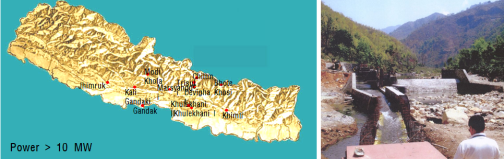
Distribution of Hydroelectric Power Plants in Nepal
|
| |
6. ҝ¬ұёұвИ№ҫИ өөГв
Proposed study plans derived
|
| |
(1) Б¶ұв °жәё ҪГҪәЕЫ ҙлАА №ж№э
(Ways of coping with the early warning system)
|
| |
|
әШұ« А§ЗиАМ Е« әщЗПИЈАЗ ҝ№°жәёҙВ јцА§ҝш°Э°ьГш, А§Зиөө Жт°Ў, БЦ№ОҙлЗЗБӨәё АьҙЮАЗ °ъБӨАё·О АМ·зҫоБц°н АЦҙЩ. јцА§әҜИӯ ёрҙПЕНёөАё·ОҙВ әщЗП јәАеҝЎ өыёҘ ұФёрёҰ БӨИ®ЗП°Ф ЖЗҙЬЗТ јц ҫш°н, БҰ№жАЗ ҫИБӨјәА» Жт°ЎЗТ јц ҫшҙЩ. ¶ЗЗС °ьГшАЪ·бАЗ БӨәё АьҙЮ Гј°и №Мәс·О АҜБц°ьё®ҝЎ ҫо·БҝтАМ АЦ°н, Бцҝш ЗБ·ОБ§Ж®АЗ °жҝм ЗцБц »уИІА» °н·БЗПБц ёшЗС јұБш№жАзұвјъ өөАФАё·О ЗБ·ОБ§Ж® Бҫ·б ИД БцјУАыАО ҝ№°жәёҪГҪәЕЫАЗ АҜБц°Ў әТ°ЎҙЙЗС ҪЗБӨАМҙЩ.
әщЗПИЈИ«јцҙВ АЪҝ¬ БҰ№жАМ БЦәҜ ұЮ°ж»зБцАЗ әШұ«ҝН јцА§ Бх°ЎҝЎ АЗЗПҝ© ИӨАә ҪәҪә·О әШұ«ЗШјӯ №Я»эЗПёз, ЗЗЗШұФёрҙВ Аъјц·®ҝЎ өы¶у ҙЮ¶уБц№З·О АМ ёрөз ҝдјТёҰ ёрҙПЕНёө ЗТ јц АЦҙВ ёЦЖј ёрҙПЕНёө ҪГҪәЕЫ ұёГаАМ ЗКҝд·О ЗПҙЩ.
|
| |
|
Precautionary and warning systems against glacier lakes highly likely to collapse are made up of remote-controlled observation, evaluation of the degree of risks, and the dissemination of information on resident evacuation. Mere monitoring of changes in the water level is not sufficient enough to evaluate the size depending on the growth of glaciers, and makes it impossible to evaluate safety of the embankment. Moreover, lack of information dissemination system makes maintenance and management difficult. Introduction of advanced disaster prevention methods without regard for the local situation in the case of supportive projects makes continuous maintenance of precautionary and warning system impossible after the project has been terminated. Flooding in glacier lakes occur when natural embankments have collapsed due to collapse of nearby sharp slopes, rise in the water level or collapse by themselves . Since the size of the damage varies depending on the amount of water stored, it is necessary to build a multiple monitoring system that makes it possible to monitor all the elements.
|
| |
|
әщЗПИЈИ«јцАЗ ҝ№°жәёҪГҪәЕЫАә ұШЗС ұвИДБ¶°ЗҝЎјӯ °иГш°ьё®°Ў °ЎҙЙЗС і»ұёјәА» әёАҜЗС јҫјӯАЗ Аыҝл°ъ әс»уҪГ ҫИБӨАыАО Аьҝш°шұЮА» А§ЗС АеДЎ°Ў ЗКҝдЗП°н, °ьГшАЪ·бАЗ АьјЫА» А§ЗС АҜ/№«јұ БӨәё ЕлҪЕ, ұЩ°Её®/ҝш°Её® АЪ·б АьјЫ №жҫИҝЎ ҙлЗС ұ№і» №жАзұвјъ°ъ Ичё»¶уҫЯ БцҝӘҝЎ АыҝлЗС ұвјъ И®әё №жҫИАМ ЗКҝдЗПҙЩ. ¶ЗЗС DEMs, А§јәҝө»у, А§ДЎБӨәёҪГҪәЕЫА» АМҝлЗС әщЗПАЗ ИДЕрҝН әщЗПИЈ јәАеҝЎ ҙлЗС ёрҙПЕНёө №жҫИ°ъ әщЗПИЈ јәАе°ъ ҝ№°жәё №Я·Й ЖЗҙЬұвБШҝЎ °ьЗС ҝ¬ұё°Ў ЗКҝдЗПҙЩ.
|
| |
|
Precautionary and warning systems need application of durable sensors that makes it possible to measure management under extreme climatic conditions and devices that can supply power sources under emergency, and wire/wireless information communications for the transmission of observed data, domestic disaster prevention technology for close and remote distance data transmitting measures and measures of securing technology applicable to the Himalayan region. Besides, measures of monitoring the retreat of glaciers and the growth of glacier lakes utilizing DEMs, satellite imaging, geographic positioning system and studies on precautionary and warning sounding standards are required.
|
| |
(2) әщЗП И«јцҝН °Зұв АҜ·® °ЁјТҝЎ ҙлЗС БҫЗХАы ҙлАА №ж№э
(Comprehensive methods of coping with glacier flooding and decreases in water flux)
|
| |
|
іЧЖИҝЎјӯАЗ јц·В №ЯАьАә іЧЖИАЗ °жБҰҝЎ ёЕҝм БЯҝдЗС ҝӘЗТА» ЗП°н АЦҫо °ијУ ГЯБшЗПБц ҫКА» јц ҫшҙЩ. ЗПБцёё әщЗП И«јцёҰ ЖчЗФЗС ө№№Я И«јц №Я»э ҪГ јц·В №ЯАь ҪГјіАМ ЖДұ«өЙ °НАМҙЩ. ¶ЗЗС АҜ·® °ЁјТҪГ јц·В №ЯАь·®АМ Е©°Ф °ЁјТЗТ °НАМҙЩ. өы¶ујӯ БцјУАыАО јц·В №ЯАьА» А§ЗШјӯҙВ әщЗП И«јцёҰ ЖчЗФЗС ө№№Я И«јц°ъ АҜ·® °ЁјТҝЎ ҙлЗС ҙлГҘ јцёі ЗКҝдЗПҙЩ.
әщЗП И«јцёҰ ЖчЗФЗС ө№№Я И«јц°ъ АҜ·® °ЁјТҝЎ ҙлЗС ҙлГҘАё·О әщЗПИЈҝН јц·В №ЯАьјТ »зАМҝЎ әщЗП И«јц №жАзҙп °Зјі ЗКҝдЗПҙЩ.
|
| |
|
Hydroelectric power generation in Nepal plays a role essential to the country's economy, thus requiring continuous upkeep. However, in case urgent flooding occurs including glacier flooding, hydroelectric power generation facilities will be destroyed. Moreover, in case the water flux decreases, the level of hydroelectric power generation will also drastically decline. Therefore, for continuous hydroelectric power generation, it is necessary to map out measures against drastic fall in hydroelectric power generation including abrupt flooding such as glacier flooding and decrease in water flux. It is necessary to build dams that will prevent glacier flooding from occurring between glacier lakes and the hydroelectric power plant.
|
| |
|
И«јц №жАзҙпА» ҝмұвҝЎҙВ ҝӯҫо іх°н °Зұв №Щ·О АьәОЕН ҙЭ°н №°А» АъАеЗТ јц АЦөө·П јі°иЗТ °жҝм °жҝм ҝмұвҝЎҙВ ө№№Я И«јц ЗЗЗШёҰ Аъ°Ё ҪГЕ°°н °ЗұвҝЎҙВ АҜ·®А» И®әёЗПҝ© АПів і»і» јц·В №ЯАьҝЎ Е« өөҝтАМ өЙ °НАМҙЩ. өы¶ујӯ И«јц №жАзҙпАә ұЧ АЪГј·ОҙВ °жБҰјәАМ ҫшА»Бц ёф¶уөө ЗП·щАЗ јц·В №ЯАь ҪГјі әёИЈҝН ө№№Я И«јц ҪГ ЗЗЗШ Аъ°Ё ұЧё®°н ҝмұвҝЎ АҜ·® АҜБц ёйА» °н·БЗТ ¶§ °жБҰјәАМ АЦА» јц АЦҫо АМҝЎ ҙлЗС АЪјјЗС°Ў ҝдұёөИҙЩ. ЗПБцёё, И«јц №жАзҙпАә јц·В №ЯАьҙп°ъ ҙЮё® °ж»з°Ў ұЮЗС °чАМ ҫЖҙП¶у °ж»з°Ў ҝПёёЗП°н ө№№Я И«јцҪГ №°А» АПҪГАыАё·О Аъ·щЗТ јц АЦҙВ °чА» јұБӨЗПҝ©ҫЯЗПіӘ АМ·ұ АејТёҰ ГЈұв Иыөйёз өҝЕдИҜ°ж, өө·О өо »зИёұв№Э ҪГјіАЗ №Мәс, °нА§өө өо ҝӯҫЗЗС °Зјі ИҜ°ж°ъ °жБҰјә ¶§№®ҝЎ ҙп °ЗјіҝЎ ҝ©·Ҝ ҫо·Бҝо БЎАМ АЦҫо ҙп °ЗјіҝЎ ҙлЗС Еёҙзјә Б¶»з°Ў ЗКҝдЗПҙЩ.
|
| |
|
Designing of flooding prevention dams that will be opened during a rainy season and closed right prior to a dry season will help decrease damages due to sudden flooding, and secure water flux during a dry period, significantly helping the power plant to run throughout the year. Therefore, even though the flooding prevention dam does not have economic value of its own, it could have economic value in view of protection of electric power generation in the downstream, reduction of damages from sudden flooding and upkeep of water flux during rainy seasons, making it necessary to conduct a detailed study on the issue. However, unlike power generation dams, flooding prevention dams should be located in places with a gentle slope where water can be stored temporarily in case of sudden flooding rather than places with a steep slope. However, such an ideal location is hard to locate, and it is difficult to build a dam due to frozen soil, paralyzed social infrastructure facilities including roads and so forth, adverse construction environment like high latitudes, and economic considerations and so forth. This makes it necessary to conduct a study on the validity of building dams.
|
| |
6. ҝ¬ұёұвИ№ҫИ
Proposed Study Plan
|
| |
ұвБёАЗ Б¶ұв °жәё ҪГҪәЕЫАә ҙп ЗП·щАЗ АҜ·® әҜИӯҝН ИЈјцАЗ јцА§ёҰ ГшБӨЗПұв ¶§№®ҝЎ БЎВчАыАО јцА§ Бх°ЎҝЎ ҙлЗС әщЗП И«јцҝЎ ҙлЗС Б¶ұв °жәё°Ў °ЎҙЙЗПіӘ »к»зЕВіӘ АЪҝ¬АыАё·О ЗьјәөИ әщЕрј® ҙпАЗ АЪГј әШұ«ҝЎ АЗЗС әщЗП И«јцҝЎ ҙлЗС Б¶ұв °жәёҙВ әТ°ЎҙЙЗПҙЩ. өы¶ујӯ АМ·ҜЗС №®БҰҝЎ ҙлГіЗТ јц АЦҙВ ә№ЗХ ёрҙПЕНёө ҪГҪәЕЫА» °®Гб Б¶ұв °жәё ҪГҪәЕЫАМ ҝдұёөИҙЩ.
Б¶ұв °жәё ҪГҪәЕЫАМ °жәс°Ў ё№АМ өй°н °ьё®°Ў Иыөйҫо іЧЖИАМіӘ әОЕә °°Аә Аъ јТөж ұ№°ЎҝЎјӯҙВ °ьё®°Ў ИыөйҙЩ. өы¶ујӯ °жәсёҰ И№ұвАыАё·О БЩАМ°н °ьё®°Ў Ҫ¬ҝо Б¶ұв °жәё ҪГҪәЕЫ ұёГаАМ ИыөйҙЩ. АМ·ҜЗС №®БҰ ЗШ°бҝЎҙВ АЪјјЗС БцҝӘ БӨәё И№өжАМ ЗКҝдЗПёз ҝмё®іӘ¶уАЗ ҫХјұ IT, БӨәёЕлҪЕ ұвјъАМ БЯҝдЗС ҝӘЗТ јцЗа ҝ№»уөИҙЩ.
Ичё»¶уҫЯ БцҝӘАә ө№№Я И«јц өоАЗ И«јц ЗЗЗШ »У ҫЖҙП¶у °ЗұвҝЎ јц·®АМ °ијУ БЩҫоөйёйјӯ іу»з, °шҫч, »эИ°ҝЎ ЗКҝдЗС ҝлјц әОБ·°ъ јц·В №ЯАьҝЎ Е« №®БҰ°Ў №Я»эөЗ°н АЦҙЩ. өы¶ујӯ әщЗП И«јц ЗЗЗШёҰ №жБцЗПёз °ЗұвАЗ јц·® әОБ·ҝЎ өыёҘ №®БҰёҰ ЗШ°бЗПұв А§ЗС №жАзҙпАМ ЗКҝдЗПҙЩ.
|
| |
|
While the existing warning system, which measures changes in water flux in the downstream of the dam and the water level in the lake, makes it possible to sound early warning signals against rises in the water level and glacier flooding, it is impossible to sound early warning signals against mountain landslides and collapse of moraine dams that has naturally formed. Therefore, an early warning system complete with a complex monitoring system that will make it possible to come to grips with such a problem is required. However, it is difficult to build and manage such an early warning system in such low-income countries as Nepal and Bhutan since such a system requires high costs and is hard to manage. Therefore, it is difficult to build an early warning system that can cut costs drastically and is easy to manage. Solution of such a problem needs detailed information on the area concerned, and this is where korea with its advanced IT technology comes into play. Serious problems are taking place in the Himalayan region for lack of water for agriculture, industry, and day to day living, and hydroelectric power generation with the water level continuously falling during dry periods as well as damages caused by sudden flooding. Therefore, disaster preventing dams are required that will prevent damages by glacier flooding and solve problems caused by lack of water during dry periods.
|
| |
|
|


